How to Use the Atlas
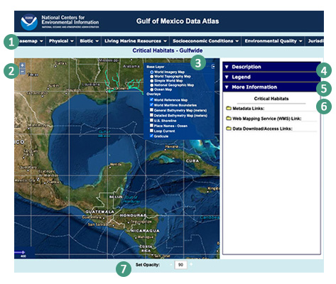
1. Menu Bar: The Atlas employs themes used in the National Ocean Service 1985 Gulf Atlas: Physical, Biotic, Living Marine Resources, Socioeconomic Conditions, Environmental Quality, and Jurisdictions. Select a theme along the top to access the datasets. Clicking on any dataset will refresh the map with the selected data, and details displayed in the right window. To reset the map to its original settings, click the reset button under Basemap.
2. Zoom: controls the zoom level of the map. Click + to zoom in. Click - to zoom out.
3. Base Layer and Overlays: Base Layer allows you to choose your base map. Overlays lets you select additional overlay maps.
4. Description: written by the data provider, or the subject matter expert. Descriptions have been peer reviewed by the Atlas Executive Steering Committee and selected scientists. A citation to reference the text and/or plate is provided.
5. Legend: an explanatory list of the symbols used on the atlas plates.
6. More Information: provides metadata for the selected plates (metadata is information about one or more aspects of the plate); it also provides access to the Web Mapping Service (WMS) to import the mapping layer (plate) into a mapping application; lastly, it provides the access to the data.
7. Set Opacity: Use the - and + buttons to set the opacity (as a percentage) for the layer.
Map Catalog
Access Map Layer by Theme
Bathymetry
Coastal Relief
Dissolved Oxygen
Extreme Natural Events
Marine Geology
Nutrients
Prevailing Winds
Precipitation
Remotely Sensed Sea Surface Temperature
Seawater Salinity
Seawater Temperature
Coastal Characterization - Gulf-wide
- Coastal Change Analysis Program (CCAP)
- CMECS Water Column Productivity Modifier
- Mangrove Communities
- Marsh Vegetation - TX, LA, MS, AL
- Wetlands
Coastal Characterization - Small Areas
Corals and Hard Bottom
- Chemosynthetic Communities
- Deep-Sea Corals
- Deep-Sea Corals - Suitable Habitat
- Petroleum Hydrocarbon Seeps
Nonindigenous Aquatic Species
Phytoplankton
Submerged Aquatic Vegetation
Food Habits
Habitats
- Critical Habitats
- Essential Fish Habitats - Council Managed Species
- Highly Migratory Species - Atlantic Bluefin Tuna
- Atlantic Bluefin Tuna - Suitable Habitat
Invertebrates
Fishes
- Atlantic Croaker
- Gag Grouper
- Gray Triggerfish
- Gulf Butterfish
- King Mackerel
- Lane Snapper
- Red Grouper
- Red Snapper
- Sand Seatrout
- Silver Seatrout
- Spanish Mackerel
- Spot
- Vermilion Snapper
- Yellowedge Grouper
Reptiles
- Green Sea Turtle
- Hawksbill Sea Turtle
- Kemp's Ridley Sea Turtle
- Leatherback Sea Turtle
- Loggerhead Sea Turtle
Sharks
Discharges
Incidents
Photic Quality
Water Quality
Boundaries
Protected Areas - Federal